
INDIAN ARMED FORCES CHIEFS ON
OUR RELENTLESS AND FOCUSED PUBLISHING EFFORTS

SP Guide Publications puts forth a well compiled articulation of issues, pursuits and accomplishments of the Indian Army, over the years

I am confident that SP Guide Publications would continue to inform, inspire and influence.

My compliments to SP Guide Publications for informative and credible reportage on contemporary aerospace issues over the past six decades.
Electronic Eye in the Sky
In a broader perspective, electro-optical devices enhance the operational capabilities of the combat aircraft fleet and precision attack weapons
With the introduction of aerial platforms in warfare, aerial reconnaissance became an important means of gathering and collation of tactical and strategic intelligence. Initially it was carried out with visual means, thereafter graduating to aerial photography, a technology that developed rapidly during World War I. The collection and interpretation of intelligence information obtained through aerial reconnaissance became a specialised area of expertise. With the development of electro-optical (EO) sensors both for voice and data as well as better means of communication, aerial reconnaissance acquired a new dimension.
With space being limited in aerial platforms such as fighter or bomber aircraft, EO devices for reconnaissance were carried in a pod on the undersurface of the aircraft. As the reconnaissance pods can carry out rapid intelligence collection, dissemination and efficient target acquisition, they provide data that helps enhance the accuracy of a strike mission. In a broader perspective, electro-optical devices enhance the operational capabilities of the combat aircraft fleet and precision attack weapons. They provide guidance for stand-off missiles and bombs to reach their targets with pinpoint accuracy.
RECONNAISSANCE PODS
Rafael of Israel is one of the leading defence companies that have developed a variety of reconnaissance pods with their variants. Examples are:
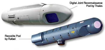
Reccelite. Reccelite is a tactical reconnaissance pod which can carry out reconnaissance missions 24 hours a day to provide real-time imagery collection and data transfer via datalink communications. It has a stabilised turret, simultaneous data collection in IR and visual channels, image collection in all directions like Horizon to Horizon/Forward-Backward, etc, real-time data link communication to ground station; operating options for high, medium and low altitudes; can share the litening targeting pod ILS infrastructure and has the option of long-range data and video down link. It has a flexible scanning operation. The LOS control is based on free stabilised turret, gimbaled inertial measurement unit, onboard terrain Data Elevation Model and sophisticated scanning algorithms. It can carry out multi-spectral, visual and IR imaging, has a multiinterpreter ground exploitation station and full duplex wideband digital data link.
LITENING AIRBORNE DAY/NIGHT NAVIGATION & TARGETING POD
Litening is an integrated targeting pod which has electro-optical devices like forward-looking infrared (FLIR), CCD camera and a laser designator for precise delivery of laser-guided munitions. It reduces the pilot’s workload during targeting and tracking; is highly accurate and reliable; reduces operational limitations; can upgrade existing aircraft with multi-mission capabilities; is combatable with most aircraft, can detect, identify and carry out laser designation of air-to-surface and maritime targets; carry out accurate delivery of laser guided munitions, cluster and general purpose weapons; laser spot detection and tracking; identification of aerial targets from beyond visual range and has the option of long-range data and video down link.
Multi-Sensor Optronic Payload Toplite. Toplite is a highly stabilised, multi-role, multi-sensor optronic payload which can operate by day/night observation and targeting. It can be configured for naval, air and ground surveillance and targeting systems. The system includes FLIR: third generation 3-5 micron or 8-12 micron TDi, CCD camera black and white or colour, eye safe laser rangefinder, laser designator (optional) and advanced correlation tracker. Toplite provides data for precision guidance for guided weapons, day or night and under adverse weather conditions. It enables observation, target detection, recognition and identification and features both manual and automatic target tracking.
Real-time ISR System for UAVs Recce-U. Recce-U is a realtime Intelligence, Surveillance and Reconnaissance (ISR) system for UAVs which can carry out persistent ISR and improvised explosive device (IED) detection. Recce-U can simultaneously collect high resolution infrared and visual digital images. A variety of scanning modes provides optimal photography of all types of terrain, combine accurate area coverage with high quality imagery. The system enables automatic photography, according to either a pre-prepared mission plan or to an updated mission plan uplinked in real-time. Additionally, the operator can initiate manual scanning for targets of opportunity. The system consists of an airborne payload, a wideband digital data link and a ground exploitation station persistent ISR scanning, IED detection capability, multiple scanning modes and high resolution day and night imagery.
THALES
Digital Joint Reconnaissance Pod (DJRP). DJRP has been developed by Thales for worldwide deployment and providesdependable operation in all climatic conditions. DJRP provides simultaneous high-resolution EO imagery and horizon-to-horizon day/night IR coverage. It delivers excellent image collection capability, fulfilling all air tactical image intelligence tasks. It can be easily integrated onto any air platform, is a robust, lightweight, low drag structure with a combat proven pedigree on numerous aircraft types including the Jaguar, Tornado, Harrier and Hawk and has been selected by the South African Air Force for the Saab Gripen. Integrating it with the seamless interoperability of Thales Networked Image Exploitation System, DJRP provides a complete cost-effective through-life airborne reconnaissance capability.
SAAB
Modular Reconnaissance Pod System (MRPS). The MRPS designed for aerial reconnaissance, is fully digitised and is built around three main system elements—the Sensor fit, the Digital Mass Memory and the Reconnaissance Management System. The system, which has provisions for both day and night capability is designed for optimum performance and can be carried on various aircraft platforms. The MRPS has been selected for the new generation of reconnaissance systems supplied to the Swedish Air Force. It satisfies STANAG NATO requirements for reconnaissance intelligence distribution.
The MRPS provides both automatic and manual control of the reconnaissance sensors. This permits the pilot to obtain quality imagery of preplanned targets and targets of opportunity. In the automatic mode of operation, the reconnaissance mission is preplanned in a ground station. The mission data is then transferred to the aircraft by means of a data transfer unit (DTU). The DTU is plugged into the aircraft and at start-up, the data is automatically downloaded to the aircraft. During the reconnaissance mission, the pilot simply has to fly the preplanned route and activate the exposure button when prompted by the system. At any stage of a reconnaissance mission, the pilot can interrupt the automatic sequence and switch to a manual mode of operation. This will allow him to manually aim and activate the sensors by use of the reconnaissance management system (RMS). Once the pilot has captured the required imagery, the automatic mission sequence can be resumed.
The 360-degree rotation window of the pod is electronically synchronised to the sensor aiming. The unique modular design of the MRPS provides customers with maximum flexibility when selecting the sensor suite. The nose and tail sections of the MRP are designed to hold data link antennas allowing the system to play an active role in the network-centric warfare scenario.
The RMS provides management and control of all equipment and functions in the pod. Video signals are interfaced to the display system in the cockpit. The ground exploitation system is based on COTS hardware and software. The system is modular and flexible and can easily be tailored to fulfill customer requirements for mission planning, image exploitation, reconnaissance reports, deployment and interoperability. A mission planning tool supports the pilot in planning the reconnaissance mission in order to obtain imagery of preplanned targets.
UTC AEROSPACE SYSTEMS
DB-110. The DB-110 reconnaissance pod from UTC Aerospace Systems is a digital, real-time, tactical reconnaissance system designed to capture images by day or night, using EO sensor technology. The pod can transmit images via data link to the ground in real time. The DB-110 is a long-range oblique sensor to provide long-range, medium-range and short-range imaging systems to support stand-off and penetrating missions. It can be operated autonomously by the pod’s reconnaissance management system. Imagery is viewed on the aircraft’s cockpit video display, enabling the pilot to verify targets and conduct tasks such as battle damage assessment.
The DB-110/Raptor. Raptor, acronym for the Reconnaissance Airborne Pod for Tornado, delivers high definition imagery in the visible and infrared bands at extremely long ranges. Its offers broad area coverage, spot and stereo coverage. The systems use an 11-inch aperture telescope with adjustable focal length of 110 inches in the visible range and 55 inches in the IR range. The EO assembly is mounted on a two-axis stabilised maintaining 180° field of view across, and ± 20° along the line of flight. The system has two-axis line-of-sight stabilisation and is compensated for ground speed range of 0.1 to 1.6 Mach at altitude above 10,000 feet. It provides variable overlap capability, from 10 to 100 per cent and panoramic scanning of four to 28 degrees.
SP's Aviation - Current Issue