
INDIAN ARMED FORCES CHIEFS ON
OUR RELENTLESS AND FOCUSED PUBLISHING EFFORTS

SP Guide Publications puts forth a well compiled articulation of issues, pursuits and accomplishments of the Indian Army, over the years

I am confident that SP Guide Publications would continue to inform, inspire and influence.

My compliments to SP Guide Publications for informative and credible reportage on contemporary aerospace issues over the past six decades.
Military Satellites and their Role in Conflicts
With varied topography that India is endowed with, satellites used for military purposes, can play a crucial role in situations of ongoing military conflict or even preceding one
A military satellite is one that is placed in orbit in space to execute functions such as communications, navigation and reconnaissance that are related to a variety of tasks for the military, on the surface of the Earth. The first time a satellite was used for a task related to the military, was a mission for photographic reconnaissance. The United States (US) was the pioneer in this field having forayed into this domain as early as in the 1950s. Later, some attempts were also made by the US to develop satellites capable of fielding weapons to be used against targets located on the surface of the Earth or in space, but efforts in this direction were discontinued in 1967 following the ratification of international treaties banning the deployment of weapons of mass destruction on satellites in orbit.
EARLY DAYS OF MILITARY SATELLITES
The very first formal military satellite programme embarked on by the US in the early 1950s, was dubbed as Weapon System 117L. This programme had under it, a number of sub-programmes one of which was named as the Corona and the initial missions undertaken under this programme were code named as Discoverer. This programme included a series of reconnaissance satellites that were designed to be launched and to be inserted into the desired orbit. These satellites were fitted with equipment on board that could capture high resolution photographs of designated areas on the surface of the Earth, both over land as well as over the sea. On completion of the photographic mission, the satellite would make a re-entry into the atmosphere of the Earth and then release the payload containing the high resolution photographs of the areas of interest on Earth via a parachute to land on the surface of the Earth either on land or over the sea. The payload could be recovered after landing.
The very first experimental mission by the US under this programme was appropriately named as Discoverer I. It was launched on February 28, 1959, but was without any payload as the intention was to first prove the budding satellite technology i.e. launch of the satellite, its entry into the desired orbit, reentry onto the Earth’s atmosphere and recovery of the payload in the designated area. The Corona programme was eventually terminated in May 1972 on account of undue interference by the Soviet Union. It was discovered by the US rather shockingly that submarines of the Soviet Navy were lurking in the recovery zone in the Pacific Ocean during the process of recovery of the payload.
For the Indian armed forces, early warning related to the military situation or developments on the ground provided by military satellites would be of critical importance
Launch and operation of military satellites was initiated by the US and this was followed by Russia, China and finally India. On account of high levels of secrecy associated with these projects, an accurate assessment of the total number of military satellites, by all four nations, currently in orbit, is difficult to estimate accurately. However, rough estimates are that as on date, there could be easily more than several thousand satellites for military use launched by all four nations listed above. Also, there are satellites currently in orbit that are capable of taking on tasks both for the military and the civil domain. Quite appropriately, these platforms are referred to as “dual use satellites”. The military role of such dual use satellites are thus easily concealed especially from nations that are not very friendly or are outright hostile.
FORAY INTO SPACE BY INDIA
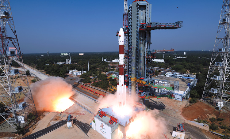
In the domain of space technology and endeavours, India has, over the years, made appreciable progress. The beginning of India’s association with space research can be traced back to the 1920s when Dr S.K. Mitra, a renowned scientist in Kolkata, conducted a series of experiments leading to the sounding of the ionosphere by applying ground-based radio methods. But space research in India received a major impetus only with the creation of the Indian Space Research Organisation (ISRO) that was established on the independence day of the nation in the year 1969 under the professionally able guidance and leadership of the legendary Dr Vikram Sarabhai. The nation’s ventures into space since then, both for military and civil use, are managed totally by ISRO.
ROLE OF MILITARY SATELLITES
In a country with varied topography that India is endowed with, satellites used for military purposes both dedicated and dual use, can play a crucial role in situations of ongoing military conflict or even a preceding one. The tasks that military satellites can be employed for, that have a direct impact on operational capability of own forces, include early warning related to movements and redeployment by enemy forces, gathering of and communicating to the appropriate agency all the intelligence information obtained on enemy forces both through electronic and signal intelligence, provide speedy and efficient communication links to own and other friendly forces deployed against the enemy in the remotest and most inaccessible areas of the country both in Jammu and Kashmir as well as in the North East.
Apart from the roles that are critical to operations by own forces, military satellites also perform the all-ubiquitous role of navigation, communications, broadcast relays and provision of meteorological data. All these are functions that can also be carried out by the systems based on the ground, but satellites do provide additional and clear advantage over systems based on the surface of the Earth as these platforms are able to expand the area of coverage globally. Besides, it would be far more difficult for the enemy to interfere with operational satellites than with surface based infrastructure for intelligence gathering. The nation’s military surveillance and reconnaissance system that provides dedicated military satellite intelligence service, has been operational since 2007 and has only been growing ever since with ISRO launching more and more satellites into orbit every year.
For the Indian armed forces, early warning related to the military situation or developments on the ground provided by military satellites, would be of critical importance. The extremely labile and volatile situation currently prevailing in Ladakh on account of the ongoing standoff between the armed forces of India and China, would be an appropriate example. In this kind of a situation, the best operational results in respect of imagery, surveillance and reconnaissance required by the armed forces can be achieved only if the coverage by satellite is uninterrupted. To achieve this, it would be necessary to insert multiple satellites into orbit to carry out these functions simultaneously to obviate the possibility of any gap or discontinuity in the flow of intelligence information that in the prevailing situation, would be a critical requirement.
Military satellites launched by ISRO that currently are operational in orbit, can provide strategic as well as tactical information on the People’s Liberation Army (PLA) deployed in Tibet and with the reconnaissance capability, the system would be able to give adequate early warning about the movement and redeployment of forces by the enemy from central China into Tibet that would have serious implications for the Indian armed forces deployed in Ladakh. It will also help the military leadership in India to assess the need for the deployment of additional forces to cope with the developing threat from the PLA.
Military satellites can also play a major role in supporting counter insurgency operations in the mountainous regions ofthe state of J&K as also the areas affected by the menace of insurgency in the North Eastern parts of the country. Military satellites can also provide images that can help in mapping the uncharted as well as forested areas that are infested with insurgents and other extremist elements. Overall, military satellites play a major role in boosting the operational capability of the nation’s armed forces.
SP's Aviation - Current Issue