
INDIAN ARMED FORCES CHIEFS ON
OUR RELENTLESS AND FOCUSED PUBLISHING EFFORTS
SP Guide Publications puts forth a well compiled articulation of issues, pursuits and accomplishments of the Indian Army, over the years

I am confident that SP Guide Publications would continue to inform, inspire and influence.
My compliments to SP Guide Publications for informative and credible reportage on contemporary aerospace issues over the past six decades.
Technology - Always a Sunny Day
With the economic crisis still simmering, Honeywell’s latest innovation is set to dramatically reduce the costs and safety issues associated with weather-related delays
Business aviation has always been at the forefront of aircraft technology. It’s where companies bring to market their latest avionics, radar systems, cabin management platforms and engine technology to deliver a premium flight experience that is unparalleled. But despite this innovation, one element that has continued to force last minute route changes, service cancellations and increased flight times that push up costs and potentially threaten safety is bad weather.
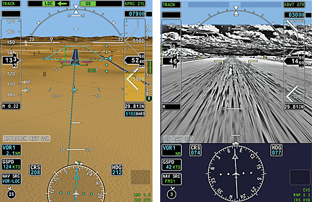
It is little wonder therefore that when Honeywell developed a technology to enable pilots to see through cloud and fog as though they were flying on a clear sunny day, a few industry eyebrows were raised. Honeywell’s SmartView enhanced and synthetic vision (EVS/SVS) is the result of thousands of hours of engineering and development, and over 100 hours of flight testing. Designed to display detailed realtime images of the terrain and key ground-based objects, EVS/SVS enables pilots to “see” runways and the surrounding land relief even in poor visibility to make approaches easier and safer.
Terrain mapping makes situational awareness simple
Before going into detail on its benefits, let’s first look how EVS/SVS works. The synthetic vision system presents pilots with a 3D graphical view of the terrain, just as the pilots might see looking out of the cockpit. The display is coupled to the aircraft’s global positioning system (GPS), giving the flight crew a display of their position in real time against the surrounding terrain. Based on a digitised database of the world’s terrain and obstacles, Honeywell’s proprietary EVS/SVS system alerts pilots approaching too close to an obstacle or terrain.
Since the late 1980s, when Honeywell first developed the database, it has continuously updated the terrain and obstacle data using feedback from users who have flown more than 800 million flight hours on about 50,000 aircraft with Honeywell’s database around the world.
Infrared–a pilot’s “x-ray glasses”
The pilots can now see their surrounding terrain and ensure that they keep a safe altitude at all times. But that is only half the problem solved, as sooner or later they will need to manoeuvre the aircraft onto its approach and land on a runway obscured by cloud cover. This is where Honeywell’s enhanced vision comes into play.
Enhanced vision blends a live video feed from an infrared camera in the nose of the plane with Honeywell’s proven synthetic vision. This enhances the view through certain bad weather conditions to reveal critical ground features such as runway approach lights or ground traffic on runways. By overlaying this image on top of the digital terrain delivered by synthetic vision, pilots receive a complete visual depiction of their flight environment that dramatically improves situational awareness in conditions that may have previously been too challenging to fly in. The display also overlays flight information such as altitude, airspeed and course further aiding pilots situational awareness.
More gadget-savvy readers may expect that the image is displayed on a super-thin light emitting diode (LED) screen on the sun visor, or projected onto the cockpit. In fact the reality is quite the opposite. Rather than over-complicating the cockpit by adding additional systems, the image is displayed via Honeywell’s integrated primary flight display (IPFD); the liquid crystal display (LCD) panels on the cockpit dashboard that pilots are already trained on. This ensures a consistent and familiar interface that is not distracting, meaning pilots spend more time concentrating on flying the plane.
SP's Aviation - Current Issue