
The insightful articles, inspiring narrations and analytical perspectives presented by the Editorial Team, establish an alluring connect with the reader. My compliments and best wishes to SP Guide Publications.
"Over the past 60 years, the growth of SP Guide Publications has mirrored the rising stature of Indian Navy. Its well-researched and informative magazines on Defence and Aerospace sector have served to shape an educated opinion of our military personnel, policy makers and the public alike. I wish SP's Publication team continued success, fair winds and following seas in all future endeavour!"

Since, its inception in 1964, SP Guide Publications has consistently demonstrated commitment to high-quality journalism in the aerospace and defence sectors, earning a well-deserved reputation as Asia's largest media house in this domain. I wish SP Guide Publications continued success in its pursuit of excellence.
Shipborne telemetry, tracking, and command (TTC) platforms fill crucial ocean coverage gaps for space launches, providing horizon extension, emergency abort command capabilities, dual-use intelligence gathering, and geopolitical independence from foreign bases.
 |
The Author is Former Director General of Information Systems and A Special Forces Veteran, Indian Army |
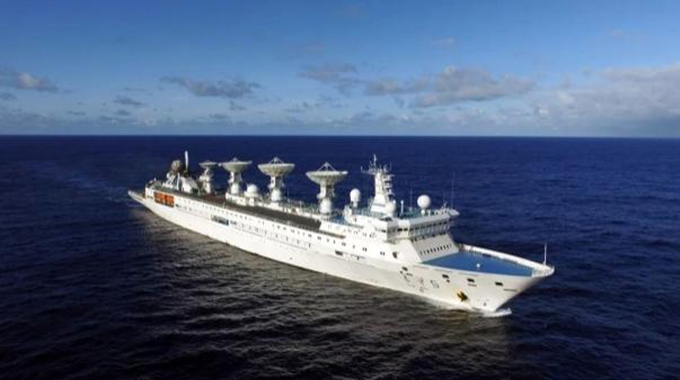
Shipborne tracking vessels provide floating telemetry, tracking, and command (TTC) platforms that fill massive communication gaps over open oceans where land-based stations cannot reach. Because the Earth is roughly 70 per cent water, standard rocket trajectories and satellite orbits frequently cross vast oceanic blind spots. Advantages of shipborne tracking include: Global Mobility - ships can position themselves directly under a spacecraft's planned flight path or orbital insertion point; Horizon Extension - overcoming curvature of the Earth, extending radar and telemetry ranges during critical mission phases like staging or re-entry; Emergency Command - vessels can transmit real-time abort or self-destruct sequences to malfunctioning rockets over deep water; Geopolitical Independence - mobile sea assets eliminate the need to negotiate or build sensitive military tracking bases on foreign soil; Dual-Use Intelligence - beyond peaceful space support, these platforms track adversarial ballistic missile tests, intercept telemetry, and map ocean topography for submarine warfare.
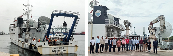
ISRO successfully validated its indigenous Ship-Borne Terminal (SBT) aboard NIOT's research vessel Sagar Manusha off Chennai, proving its ability to track rockets and satellites from a moving maritime platform without relying on foreign infrastructure.
According to news reports of July 19, 2026, the Indian Space Research Organisation (ISRO) has successfully validated its indigenous ship-borne tracking terminals aboard the research vessel 'Sagar Manusha' of the National Institute of Ocean Technology (NIOT), marking a major leap in India's space programme. This breakthrough ensures reliable tracking of rockets and satellites over oceans, strengthens mission safety, and is crucial for the upcoming Gaganyaan human spaceflight mission.
The successful trial of ISRO's Telemetry, Tracking and Command Network (ISTRAC) was conducted on July 26, 2026 aboard Sagar Manusha off the coast of Chennai. The system was tested under real maritime conditions and proved its ability to function effectively from a moving platform, validating its operational readiness. After liftoff rockets quickly traverse oceanic regions, where terrestrial tracking infrastructure cannot reach. The indigenous Ship-Borne Terminal (SBT) is designed to track launch vehicles and satellites once they move beyond the coverage of ground-based stations.
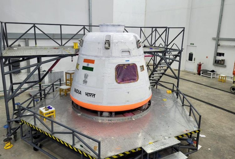
The SBT bridges the gap of terrestrial tracking infrastructure by ensuring uninterrupted communication and monitoring during critical mission phases. This capability is particularly vital for human spaceflight missions, where continuous monitoring of the crew module and launch vehicle is essential for safety. The system will play a central role in the Gaganyaan mission, India's first human spaceflight programme. It will allow mission controllers to maintain real-time contact with astronauts and the spacecraft even when flying over the Indian Ocean and other remote regions.
ISRO's successful validation of its indigenous ship-borne tracking terminals will ensure better safety, rapid response to emergencies, and accurate trajectory tracking. The technology also supports satellite missions by providing coverage in areas without land-based infrastructure, thereby expanding India's operational flexibility. This validation of the SBT demonstrates India's growing self-reliance in critical space infrastructure. Until now, such capabilities often depended on foreign systems or limited international tracking networks.
The new shipborne terminal provides uninterrupted communication and real-time crew module monitoring during oceanic flight phases, serving as a core safety component for the upcoming Gaganyaan human spaceflight mission and future deep-space exploration.
By developing and deploying its own ship-borne terminals, India reduces dependence on external technologies, lowers costs, and enhances mission security. This achievement reflects ISRO's broader strategy of building indigenous systems to support ambitious projects like Gaganyaan and future deep-space missions. The collaboration between ISRO and NIOT highlights the integration of maritime and space expertise.
The Sagar Manusha research vessel served as a mobile platform for the trials, showcasing India's ability to deploy advanced tracking systems at sea. This synergy strengthens India's space mission support infrastructure and ensures readiness for both uncrewed and crewed launches. Beyond Gaganyaan, the ship-borne terminals will be invaluable for satellite launches, interplanetary missions, and deep-space exploration. They provide India with the flexibility to track spacecraft across remote oceanic stretches, reinforcing the country's position as a rising space power. The successful trial marks a milestone in India's journey towards greater autonomy in space operations and sets the stage for safer, more reliable missions in the years ahead.
While India is expanding its capabilities, Pakistan recently inducted its first specialised Chinese-assisted spy and tracking vessel, PNS Rizwan, which can monitor Indian space and missile tests in the Arabian Sea on behalf of China under a low-profile guise.
The existing research fleet of the NIOT, managed by NIOT's Vessel Management Cell (VMC) includes: Sagar Nidhi (Ocean Research Vessel), Sagar Manusha (Buoy Tender Vessel), Sagar Tara (Coastal Research Vessel), Sagar Anveshika (Coastal Research Vessel).
The US and China possess the world's most dominant maritime space-tracking architectures. Pakistan has no indigenous capability to conduct shipborne tracking of space systems, but it has acquired this capability entirely through direct military and technological assistance from China. Pakistan has already inducted its first specialised spy and tracking vessel, PNS 'Rizwan', to monitor regional space and missile activities. The 87-metre-long vessel was spotted on open-source intelligence (OSINT) networks before its low-profile induction. It is equipped with three large, distinctive radomes that house specialised telemetry radars, electronic intelligence (ELINT) sensors, and satellite communication terminals. The vessel is frequently classified on commercial tracking systems as a standard "offshore supply ship" and routinely turns off its Automatic Identification System (AIS) to obscure its operations. It is presumed that by embedding tracking equipment on a Pakistani naval hull, China can effectively monitor Indian missile tests from the Arabian Sea without deploying its own Yuan Wang ships directly into politically sensitive waters.
Satellites can also actively track the space missions, rocket launches, and satellites of adversary countries, the capability termed Space-Based Surveillance (SBS). These specialised satellites look outward into space to monitor adversary rocket trajectories, orbital manoeuvres, and secret satellite deployments in real time. Only a few spacefaring nations like the US, Russia and China, possess the extreme technological proficiency required to operate space-based tracking architectures.
Beyond maritime tracking, global powers operate Space-Based Surveillance networks to track adversary satellites and launches in real time—a space domain capability led by the US and China that India is moving to match via upcoming constellations like SBS-III.
The US Space Force operates the world's most sophisticated and expansive space-surveillance network: Geostationary Space Situational Awareness Program (GSSAP) a constellation of highly manoeuvrable satellites operating near Geostationary Orbit (GEO) that can sneak up on adversary military satellites; Space-Based Space Surveillance (SBSS)- Satellites in Low Earth Orbit (LEO) equipped with high-speed digital cameras that track thousands of deep-space objects daily.
Chinahas rapidly matched US capabilities, deploying an intricate network of dual-use constellations and dedicated space-surveillance platforms: Shiyan Constellation - China frequently uses its Shiyan series satellites to test orbital proximity operations - satellites like Shiyan-12 and Shiyan-21 have demonstrated advanced capabilities by approaching and stalking Western satellites to map their configurations; Tongxin Jishu Shiyan (TJS) - nominal communications test satellites, these secret platforms are heavily assessed to perform space signals intelligence and early warning tracking.
India is reportedly also expanding its Space-Based-Surveillance network with upcoming projects like the SBS-III constellation, aiming to secure autonomous tracking of regional maritime and space domains.