INDIAN ARMED FORCES CHIEFS ON OUR RELENTLESS AND FOCUSED PUBLISHING EFFORTS

The insightful articles, inspiring narrations and analytical perspectives presented by the Editorial Team, establish an alluring connect with the reader. My compliments and best wishes to SP Guide Publications.

"Over the past 60 years, the growth of SP Guide Publications has mirrored the rising stature of Indian Navy. Its well-researched and informative magazines on Defence and Aerospace sector have served to shape an educated opinion of our military personnel, policy makers and the public alike. I wish SP's Publication team continued success, fair winds and following seas in all future endeavour!"

Since, its inception in 1964, SP Guide Publications has consistently demonstrated commitment to high-quality journalism in the aerospace and defence sectors, earning a well-deserved reputation as Asia's largest media house in this domain. I wish SP Guide Publications continued success in its pursuit of excellence.


- Prime Minister Modi Visits Punjab’s Adampur Air Base, Interacts with Airmen after Successful ‘Operation Sindoor’; Stern Message to Pakistan
- The layered Air Defence systems that worked superbly, the key element of Operation Sindoor
- Operation Sindoor | Day 2 DGMOs Briefing
- Operation Sindoor: Resolute yet Restrained
- India's Operation Sindoor Sends a Clear Message to Terror and the World – ‘ZERO TOLERANCE’
- Japan and India set forth a defence cooperation consultancy framework, talks on tank and jet engines
LiDAR Satellites
Considering the enlarging threats to India and with the possibility of conflict with China and its allies in the short, medium and long terms, our scientists, policy makers and military planners need to examine the military applications of satellite-based LiDAR platforms
 |
The Author is Former Director General of Information Systems and A Special Forces Veteran, Indian Army |
LiDAR is an acronym for Light Detection And Ranging. Like radar, LiDAR is an active remote sensing technology, which instead of using radio or microwaves uses light. Since LiDAR systems provide their own energy they can be used by day or at night. However, while LiDAR can be used at night, it cannot penetrate clouds and rain and therefore can only acquire data in fair conditions. At the same time LiDAR produces extremely accurate and precise data, often with centimeter level accuracy. This is because LiDARs are similar to radars in remote sensing but at optical wavelength; because of the much shorter wavelength, lasers can be modulated much faster and the laser beams can be collimated to a much smaller spot on the ground. As a result, LiDARs generally have much higher temporal and spatial resolutions, and smaller instrument sizes.
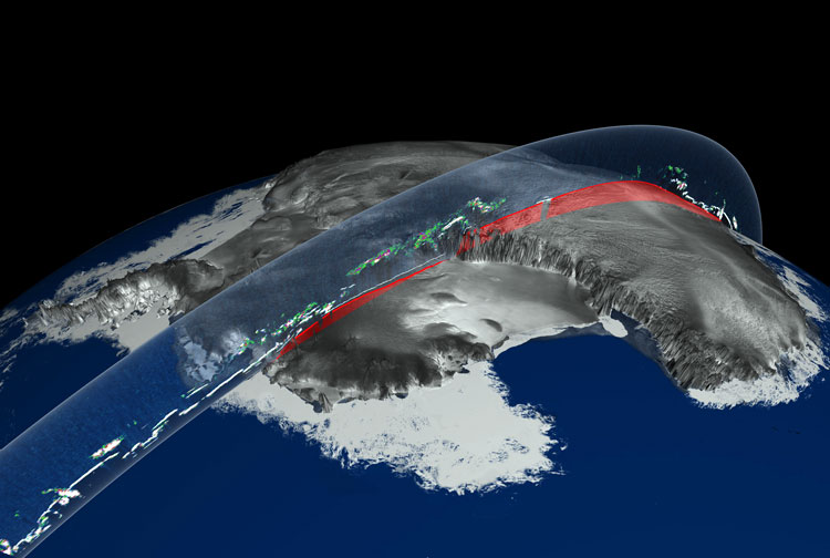
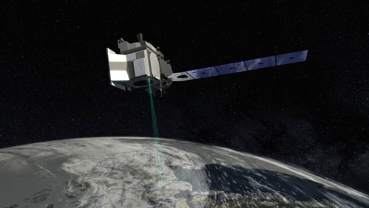
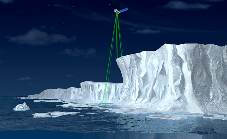
LiDAR platforms mounted on satellites orbit the Earth. NASA's Ice Cloud and Land Elevation Satellite (ICESat) carried the Geoscience Laser Altimeter System (GLAS) which collected data on global cloud cover, vegetation canopy and polar ice caps. A space-based LiDAR system was installed on the International Space Station in January 2015. NASAs ICESat-2, the follow-up to the first satellite was launched in 2018. The Cloud-Aerosol Transport System (CATS) is designed not to measure the Earth's surface but to use LiDAR to analyse and measure the particles in the Earth's atmosphere. The Global Ecosystem Dynamics Investigation (GEDI) is a LiDAR sensor installed on the International Space Station in 2019. The mission of GEDI is to produce high resolution laser ranging observations of the 3D structure of the Earth.
Considering the enlarging threats to India and with the possibility of conflict with China and its allies in the short, medium and long terms, our scientists, policy makers and military planners need to examine the military applications of satellite-based LiDAR platforms
An article published in 2016 observed following usage of LiDAR in India from the geospatial perspective: power-line transmission and pipeline corridor planning; earthquake study and disaster management; space and planetary studies; urban modeling; oil and gas exploration surveys; transportation studies and surveys including road, rail, air and sea; climatic study; flood risk mapping; forestry; study on airport exclusion zones; high-resolution mapping and 3D modeling; coastal zone mapping, and; rectification of satellite imagery. The article mentioned Indias ambitious project for urban renewal of 63 cities (JNURM) costing 12,05,360 million while a fraction of this investment could help in providing data to guarantee the success of the mission.
The above article recommended that government concerns could be addressed within a geopolitical context through a workshop to figure out the issue of security and high-resolution data. Further, airborne remote sensing needed to be deregulated and the process for obtaining survey permission made more efficient and transparent. It also suggested that the geospatial education system will need to look at LiDAR as an important remote sensing option, building it into the curriculum.
Another article published in foreign media this year highlights that supporting new weapons such as strategic hypersonic missiles depends on delivering high-quality ISR in tactically relevant timelines. But NASAs LiDAR doesnt deliver the high-resolution, 3D, foliage-penetration imagery or even tactical timelines the military needs; intelligence and military planners along with field operators need a space-based LiDAR capable of rapidly surveying large areas at very high resolution in a single pass.
Department of Science and Technology (DST) has announced Indias geospatial mapping guidelines for Indian geospatial technology sector
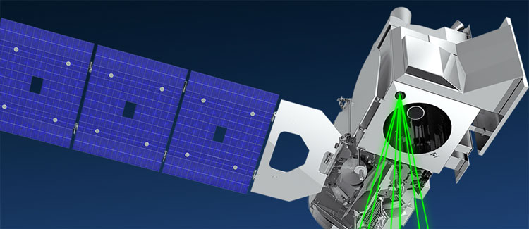
For this, the article suggests a promising new concept, based on proven technology, for a multi-aperture, space-based LiDAR satellite system with multiple telescope receiver modules observing a single target. This concept relies on a laser pulse from a single-photon LiDAR system that reflects from the target. The signal photons propagate not only gets back to the transmitter but also in other directions. These results could provide unmatched visibility of a denied area of interest alongside the data necessary for more effective and accurate use of advanced weapon systems.
Considering the enlarging threats to India and with the possibility of conflict with China and its allies in the short, medium and long terms, our scientists, policy makers and military planners need to examine the military applications of satellite-based LiDAR platforms. This is essential since we too akin to the US are acquiring hypersonic platforms and possess long-range precision weapons. These will require matching space-based ISR to succeed since airborne ISR aircraft will be priority targets for the enemy and have limited standoff capability.
The Survey of India (SOI) has special responsibility to survey and mapping of India to help integrated development. However, the discharge of its duties are tangled in red-tape; several permissions from various authorities despite the fact that same geospatial data is available globally. Similar hardships are experienced to obtain geospatial data from ISRO/NRSA/SAC though Indian Space Research Organisation (ISRO) though it has done a commendable job in satellite launching for the benefit of several sectors and collected the wide range of remote sensing data with impressive resolution standards. Same is the difficulty in conducting surveying and data collection using drones and LiDAR technologies over a known area. This not only stonewalls private sectors commercial projects but also affects academic researches due to lack of access to proper data.
As part of the digital revolution, India has witnessed many cutting edge technologies helping various sectors and advancements towards Big Data, Machine Learning, IoT and Digital Twin. However, the Indian geospatial industry faced many setbacks, some of which are, lack of access to reliable and context specific geospatial data; lack of overall policy and guidelines for ease of access; lack of clear understanding of data sharing and storage policies, and; lack of access to Continuously Operating Reference Stations (CORS) network.
On February 15, 2021, The Department of Science and Technology (DST) announced Indias geospatial mapping guidelines for Indian geospatial technology sector. The DST press release outlined major objectives and guidelines on data acquisition, services and data sharing; liberalising and deregulating the way geospatial data has been made available and exchanged till now How these guidelines will be executed on ground only time will tell.
India has traditionally given low priority to defence and operational requirements of the military. The gaps in our ISR were more than evident last year when the Chinese surprised us in Eastern Ladakh. The intelligence sharing agreement with the US didnt work either because Americas priority is waters of the Indo-Pacific, not the threat to us across the Himalayas. The official line that we were aware is nonsense because if we were aware why did we not mobilize in time? Finally, it is reiterated that in order to support our hypersonic platforms and long-range missiles we must examine satellite-based LiDAR systems as part of the advanced ISR project.
SP's Aviation - Current Issue