INDIAN ARMED FORCES CHIEFS ON OUR RELENTLESS AND FOCUSED PUBLISHING EFFORTS

The insightful articles, inspiring narrations and analytical perspectives presented by the Editorial Team, establish an alluring connect with the reader. My compliments and best wishes to SP Guide Publications.

"Over the past 60 years, the growth of SP Guide Publications has mirrored the rising stature of Indian Navy. Its well-researched and informative magazines on Defence and Aerospace sector have served to shape an educated opinion of our military personnel, policy makers and the public alike. I wish SP's Publication team continued success, fair winds and following seas in all future endeavour!"

Since, its inception in 1964, SP Guide Publications has consistently demonstrated commitment to high-quality journalism in the aerospace and defence sectors, earning a well-deserved reputation as Asia's largest media house in this domain. I wish SP Guide Publications continued success in its pursuit of excellence.
- The layered Air Defence systems that worked superbly, the key element of Operation Sindoor
- Operation Sindoor | Day 2 DGMOs Briefing
- Operation Sindoor: Resolute yet Restrained
- India's Operation Sindoor Sends a Clear Message to Terror and the World – ‘ZERO TOLERANCE’
- Japan and India set forth a defence cooperation consultancy framework, talks on tank and jet engines
Communications - Webbed Solution

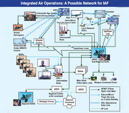
Riding on a combination of mediums, like fibre-optics and satcom, the IAF could become capable of conducting network-centric air operations
The ability to collect, Process and disseminate flow of information leading to increased mission space awareness and subsequent dominance constitutes the essence of present-day air operations—firmly fixed in a classical extended C4ISR framework (Command, Control, Communications, Computers, Intelligence, Surveillance and Reconnaissance). Success of such operations is ensured through shared situational awareness, close collaboration, co-ordination of capabilities and the ability to react quickly to highly dynamic modern airborne threats.
Networking of widely dispersed ground-based sensors (radars, visual observation posts, passive electro-optical and radio frequency sensors), multi-spectral sensors on a host of airborne platforms (combat aircraft, Airborne Warning and Control System, or AWACS, Unmanned Aerial Vehicles, or UAVs, aerostats, and so on) and processing of massive data flow from such diverse sources to generate a comprehensive air picture in a defined air volume has become the foremost task in the conduct of not only the air defence (AD) but, the entire gamut of air operations. The air scenario—referred to as operational situation picture (OSP) or air situation picture or recognised air picture—has to be both comprehensive and stable to serve as the main source of information for decision making at various echelons of the command structure.
In the past, creation of air picture, involving two or more sensors, was done manually. However, since the quality of decisions that emanate at various levels of a networked system (in the areas of threat evaluation, force application and battle management) depends directly upon the quality of air picture, the manual, or so-called semi-automatic networks, were found to be inadequate for controlling modern day air operations. While the air picture becomes the essential tool for operational decisions, a host of decision support tools are incorporated in the system for mission planning, threat prioritisation, weapon selection and threat engagement for the conduct of efficient and effective air operations.
Evolution & Expansion
As technology continued to evolve in terms of better sensors and computing power, technologically advanced air forces the world over re-defined the roles, functions and responsibilities of the then existing conventional organisations and its intervening command echelons to encompass all air operations and not remain confined to AD functions alone. It was but a natural evolution.
For effective air operations, air space management being a precondition, a total knowledge of spatial orientation of all friendly air vehicles (fighters, transport aircraft, surveillance platforms, armed helicopters, UAVs, and so on) in the given air space became mandatory. With such data being available, conduct of all air operations such as mission planning of own aircraft, storage and dissemination of target data, issue of air tasking orders to bases, control of support elements (tankers, UAVs, AWACS), tactical routing to avoid space and time conflict, search and rescue operations, and so on from a single control centre made logical sense. The AD Control Centres thus evolved in to Air Operations Control Centres (AOCCs), while the intermediate node, normally called the AD Direction Centre (ADDC) in the earlier structure, was either replaced by a Control and Reporting Centre (CRC) or eliminated altogether, depending upon the geographical factors and traffic density. For the AOCC to function effectively, a reliable, robust and secure communication network was almost a precondition. Narrow band dedicated point-to-point links had to, therefore, make way for highly secure broadband data backbones capable of handling large volume of voice, data and video signals.
At the functional level, it translated into establishing a Central AOCC, regional centres and sub-regional control nodes connected to air bases, missile command posts, autonomous AD zones, civil air traffic control centres and ground-based sensors (mobile observation posts, radars of various types and a number of remote facilities). This ground network was dynamically linked to AWACS, Joint Surveillance and Target Attack Radar System, Airborne Early Warning, and local networks between combat aircraft.
Compared to other advanced and more modern air forces, especially of the western world, how did things shape up in the Indian Air Force (IAF)? Like all other air forces, the evolutionary process in the IAF also progressed through the AD route which, itself, acquired a formal structure only after the 1962 war with China. Following the 1962 setback, new hardware and command and control (C2) structure were acquired and the doctrine defined, to establish the AD network with active assistance from the US. ADDCs, collocated with high powered Westinghouse Star Sapphire radars, were established as the nodal points for regional AD and tropo-scatter communication links engineered between major nodes. The C2 structure then established has continued to survive till date, albeit with certain modifications. As the low level air threat became progressively more significant, Base AD Centres and CRCs were created for point and limited area defence, respectively, all linked to an ADDC but with a degree for autonomy in terms of decision making and response to emergent air threats.


