INDIAN ARMED FORCES CHIEFS ON OUR RELENTLESS AND FOCUSED PUBLISHING EFFORTS

The insightful articles, inspiring narrations and analytical perspectives presented by the Editorial Team, establish an alluring connect with the reader. My compliments and best wishes to SP Guide Publications.

"Over the past 60 years, the growth of SP Guide Publications has mirrored the rising stature of Indian Navy. Its well-researched and informative magazines on Defence and Aerospace sector have served to shape an educated opinion of our military personnel, policy makers and the public alike. I wish SP's Publication team continued success, fair winds and following seas in all future endeavour!"

Since, its inception in 1964, SP Guide Publications has consistently demonstrated commitment to high-quality journalism in the aerospace and defence sectors, earning a well-deserved reputation as Asia's largest media house in this domain. I wish SP Guide Publications continued success in its pursuit of excellence.


- The layered Air Defence systems that worked superbly, the key element of Operation Sindoor
- Operation Sindoor | Day 2 DGMOs Briefing
- Operation Sindoor: Resolute yet Restrained
- India's Operation Sindoor Sends a Clear Message to Terror and the World – ‘ZERO TOLERANCE’
- Japan and India set forth a defence cooperation consultancy framework, talks on tank and jet engines
Neighbourhood - The PLAAF in Tibet
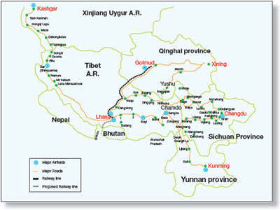
China’s military capability in and around Tibet Autonomous Region and its implications for the IAF
Despite the high decibel rhetoric flowing from both sides on territorial claims and counterclaims, it is unlikely India and China will be involved in a shooting war in the near future as both countries concentrate on economic growth and domestic issues. The meeting between the Prime Ministers of the two countries in Thailand on October 24 has cooled the temperature somewhat. But, while China follows the “24 character strategy” propounded by Deng Xiao Ping, India would do well to remember General Sundarji’s wise words, “Being weak is not virtuous, being prepared is not provocative.”
A 4,000 km long border between India and China remains unsettled due to historical reasons. After China assimilated Tibet into the Peoples’ Republic and India accepted this fact, many areas along the border remain disputed despite endless but fruitless joint meetings between the representatives of the two countries.
Tibet Autonomous Region (TAR) is the shrunken remains of a much larger Tibet. It is 1,222,000 sq km in area with Xingjiang Uyghur Autonomous region to its north. In its east are the provinces of Sichuan and Yunnan. In the south are Myanmar, India, Bhutan and Nepal. To its west lies more Indian territory. It has an average elevation of 4,900 m and the Tibetan Plateau is the highest region on earth. It is isolated by the Himalayan ranges to the south, Karakoram ranges to the west and Kunlun Mountains to the north. South TAR is situated entirely in the Himalayas with Mount Everest at 8,850 m being the highest peak. Kailash range, an offshoot of the Himalayas, branches off to the north and then runs parallel to the main chain. Between Kailash range and the main chain is a river valley that extends 1,000km. Brahmaputra river flows from west to east along a major part of this valley. The Ganges, Indus and Sutlej rivers have their headwaters in Western Tibet, while those of Mekong, Yangtze and Huang Ho (Yellow River) rivers are in Northern Tibet.
TAR is divided into seven Prefectures with capital Lhasa being a City Prefecture. There are 2.7 million Tibetans in TAR and an additional 2.7 million in adjacent areas. In contrast, the Chinese Han population is estimated at 7.2 million. The ratio of Tibetans to Han in the cities of TAR is 1:3, while the Tibetans are the majority in rural areas. There is simmering discontent among the Tibetans about this creeping ‘Sinocisation’ of TAR through Han migration and economic marginalisation of the native population.
Chinese Presence & Power
China has constructed 14 major airbases in the Tibetan Plateau and there are about 20 airstrips like those in Arunachal Pradesh. China’s People’s Liberation Army Air Force (PLAAF) has established bases at Hoping, Pangta, Shiquanhe, Bayixincun (in Central Tibet opposite Arunachal Pradesh) and Kong Ka. There are two airfields at Lhasa, airfields at Shannan, Xigaze and an additional four in the sector which can be made operational quickly. Many have runways of 4,000 m length. A major airfield has been constructed at Nyingtri at Linzhi in SE TAR. Lhasa is connected to Beijing, Chengdu, Shanghai, Guangzhou, Chongqing, Xian and Xinin by domestic flights. There are a few international flights also. Most airfields can accommodate operations by civil aircraft of the Boeing 767 and Airbus 340 class. China has the capability to transfer 12 divisions in 30 days into the TAR from other regions.
Beijing’s vastly improved heavy lift capability over long distances was demonstrated during the Exercise Stride-2009. In this largest ever tactical exercise conducted by Chinese armed forces, 50,000 troops were moved from five provinces in 13 days to North East China. Troops opposite Taiwan or those in Beijing Province were not deployed. Chengdu province opposite India did not participate in the exercise. PLAAF aircraft and requisitioned civil airliners were employed for this massive airlift. Rail transportation was also used to move heavy weapons on flat bed trailers with troops travelling in passenger coaches. Those participating in Stride-2009 included People’s Liberation Army (PLA) infantry, PLAAF, Special Operations Units, army aviation troops, electronic warfare companies, photo reconnaissance units, Unmanned Aerial Vehicle groups, and short wave interference stations. China’s indigenous satellite navigation and positioning system, BEIDOU, was utilised for communications during the exercise to maintain confidentiality and more importantly, to avoid dependence on foreign systems.
While Tibet was not activated during Stride-2009, a message was conveyed to China’s neighbours and the rest of the world that Beijing has the capability to move large military formations in compressed time periods. The rail line from Golmud in Qinghai to Lhasa, completed in 2006, adds a new dimension to China’s build-up in TAR. This 1,142 km long rail line, laid over permafrost, connects Lhasa to Beijing, Shanghai, Chengdu, Guangzhou and Xining. The over 4,000 km run from Lhasa to Beijing is covered in about 48 hours. China has plans to build 13,000 km of high speed rail tracks by 2012. Of this, 185 km has been completed. These tracks are compatible with trains running at speeds in the region of 350 kmph. The tracks over permafrost can accept speeds of up to 120 kmph. There is the danger of climate change processes affecting the longevity of the tracks laid on permafrost and these are also vulnerable to heat creating munitions.
China has plans to extend the rail network up to the Tibetan town of Dromo, which is near Nathu La and Sikkim. China is deploying ICBMs DF-31 and DF-31A at Delingha which lies north of Tibet and these can target the entire Indian sub-continent. The Karakoram Highway is to be widened to 30 m from the present 10 m to permit heavy vehicles to negotiate this route. While ostensibly for augmenting the carrying capacity from Karachi port into China, the military implications are obvious.
SP's Aviation - Current Issue